top of page


Scouting
Get a Bird's-Eye View of the Land
Find issues before they hit your yield. Our aerial drone scouting services give you a fast, accurate look at your crops from above, pinpointing problems that can't be seen from a truck seat.

Clear and Detailed

Precise Mapping


Insight into Action
A complete aerial view of your land, crops, or property.
Detailed orthomosaic maps with clear, actionable insights.
Identify issues early and make confident decisions.
What Scouting Drones Do
Aerial drones provide a fast, efficient way to survey large areas from above, capturing details that are easy to miss from the ground.
-
Traverse difficult terrain and inaccessible locations
-
Capture full-property views in a single flight
-
Identify issues early before they spread or worsen
-
Reduce time spent walking fields or inspecting structures
-
Create visual records for tracking changes over time
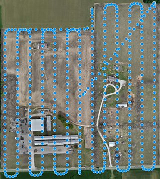
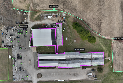
Orthomosaic Mapping
We use advanced image processing software to stitch hundreds of pictures together into a precise, detailed map.
-
High-resolution, georeferenced images
-
Annotated maps highlight key findings, such as:
-
Roof damage
-
Sinkholes or wet areas
-
Object counts and property features
-
-
Ideal for reporting, record-keeping, and decision-making
Crop Health
Multispectral imaging reveals what is invisible to the human eye.
-
Detect crop stress and variability across fields
-
Identify drainage issues and water pooling
-
Monitor emergence and stand consistency
-
Evaluate storm or weather damage
-
Improve yield potential through earlier intervention

Industries Served
Our reports and imagery support professionals who need accurate, visual documentation to assess conditions, plan work, and communicate findings.
-
Farmers and agronomists
-
Property and real estate
-
Insurance and claims
-
Golf courses and campuses
-
Land management and conservation

2026 Special
Join our Summer Fungicide Program for a free scouting mission, priority scheduling, and discounted rates on multiple applications.


About Scarecrow Technologies
Quick Links
Contact Us
Scarecrow Technologies, LLC
7450 West 1125 North
New Richmond, IN 47967
(765) 715-4677
info@scarecrowtechnologies.com
Your trusted partner for ag drones and field services.
bottom of page